
confident of handling Gustav aftermath
Port Fourchon (Louisiana): Hurricane-force winds slammed into oil terminals around Port Fourchon, southwest of New Orleans, as the eye of Category 2 Gustav was churning just off the Gulf shore Monday morning, according to radar.
According to forecasts, Gurustav — which was downgraded to a Category 2 when its winds weakened to 110 mph Monday morning — is expected to skim New Orleans, which is still recovering from 2005's Hurricane Katrina.
Port Fourchon is packed with oil terminals and distribution facilities. It is the terminal for tankers bringing oil to the US from overseas. The US Department of Energy says 56 percent of the imported and Gulf of Mexico oil entering the United States passes this point.
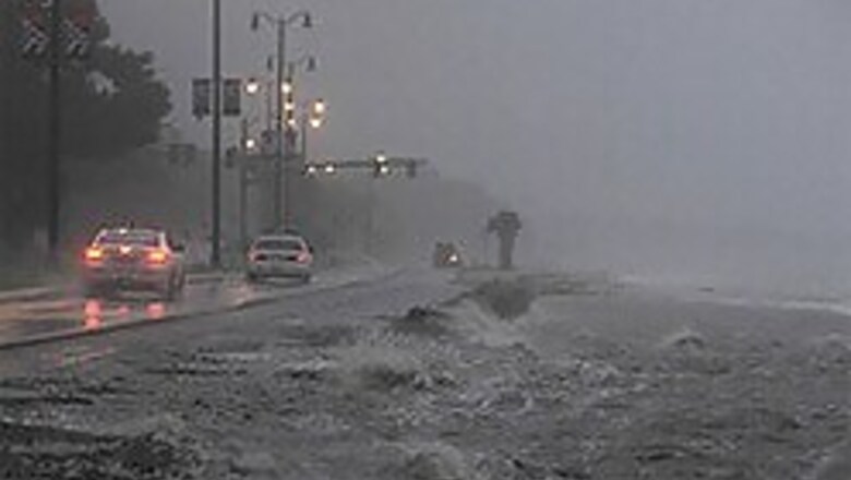
Grand Isle, in the middle of Gustav's path, was covered in water, and lights were extinguished in parts of downtown New Orleans, including the French Quarter and Children's Hospital.
"If you look down the river, you can see whitecaps on the Mississippi going against the current," CNN's Rob Marciano said from downtown New Orleans.
There are concerns that if Gustav moves up the Mississippi's estuaries, some levees may not hold, resulting in severe flooding. Although many levees have been repaired and heightened since Hurricane Katrina struck in 2005, all of the work won't be completed until 2011, officials say.
The US Geological Survey says Gustav has already caused a nearly 9-foot storm surge in Pointe a La Hache, Louisiana, about 40 miles southeast of New Orleans. Another 1 to 3 feet of surge could occur, the USGS said.
Forecasters warned that a surge of 10 to 14 feet would cause life-threatening flooding. The elevation of the town, the seat of Plaquemines Parish, is 3 feet above sea level.
Beth Raley, a spokeswoman for Entergy power, said about 92,000 customers had lost power by 8 a.m.
Around 8 a.m., Children's Hospital lost power and switched to generators. A short while later, East Jefferson General Hospital lost power and was running on generators.
CNN's Ali Velshi was hunkered down in a house on Grand Isle, Louisiana, south of New Orleans, where only a handful of people remained.
When high winds first kicked up about 3:15 am (4:15 am ET) Monday, the barrier island's electric power went out, Velshi said. A storm surge of at least 14 feet is expected there, he said.
"The levee on the beach seems to be holding up," said Grand Isle Fire Captain Deacon Guidry. "The water is just starting to rise from the bay side."
Guidry completed an inspection tour of the island just before dawn. He said that he saw sheet metal from roofs on the road and power lines down, even before Gustav's powerful winds had reached the island.
Guidry, who is staying with others from the island in a reinforced house, said the flooding pattern is similar to that of Katrina, with the storm surge washing over from the backside of the island. At 6:30 a.m. ET, floodwaters surrounded the house, cutting off all exits from the island.
The US Army Corps of Engineers closed flood gates on the Harvey Canal on the west bank of the Mississippi River on Monday. The step, not unexpected, is the first significant measure to prevent flooding of parts of Jefferson Parish that did not flood during Katrina.
Tornado warnings were issued Monday morning for southeastern Louisiana, southern Mississippi, northwestern Florida and southwestern Alabama as Gustav moved through the region, according to the National Weather Service.
Property damage from Gustav could total $8 billion, just 25 percent of Sunday's estimate, according to a federally supported computer projection issued Monday morning. Sunday's estimate of $32.8 billion in property damage was based on winds of 126 mph.
The projection now says about 78,036 buildings will be moderately damaged and 13,286 buildings destroyed. It estimates Gustav will leave behind 13 million tons of debris, less than half of Sunday's projection.
Forecasters warned Monday morning Gustav could stall over Louisiana and northeast Texas for several days, which would "exacerbate the threat of heavy rains and inland flooding."
With hurricane-force winds extending 70 miles (113 kilometers) from the storm's center, the islands and shoreline were already feeling the reach of Gustav's fury. Sustained winds of 91 mph (146 kph) and gusts of 117 mph (188 kph) were measured in Southwest Pass, Louisiana, around 4 a.m., the hurricane center said.
Gustav's center was about 85 miles (137 kilometers) south of New Orleans and about 20 miles south-southeast of Port Fourchon, Louisiana, at 6 a.m. (7 a.m. ET), the hurricane center said.
Gustav was moving northwest at about 16 mph (26 kph), headed for an expected landfall on Louisiana's coast southwest of New Orleans around midday, the hurricane center said.
Gustav's winds make it a dangerous Category 3 storm, but no more strengthening was expected before landfall, the hurricane center said.
Nearly all of the roughly 2 million people in coastal Louisiana and the New Orleans area had cleared out ahead of Gustav on Sunday night.
Road, rail and air links out of New Orleans began to close as the first storm bands began to strike the city. But fewer than 10,000 people were thought to remain in New Orleans, Louisiana Gov. Bobby Jindal said, citing the city's police chief.
New Orleans Mayor Ray Nagin had demanded an evacuation of the city, which still is recovering from Katrina.
Jindal said New Orleans' levees should "barely hold or barely be overtopped" if the storm, as predicted Sunday evening, hit southwest of the city.
But even a slight shift to the east could bring "very significant flooding in these areas," he said.


Comments
0 comment