
Himachal Pradesh received snowfall while the minimum temperatures in many parts of north India hovered above normal levels on Thursday, even as the IMD predicted rainfall in many southern states. In the south, the Karnataka State Disaster Management Authority sounded a yellow alert in the coastal and Malnad regions as the upper air cyclonic circulation brought heavy showers in many parts of the state. The India Meteorological Department (IMD) said heavy to very heavy rainfall was observed at isolated places over Kerala and Mahe while heavy rainfall also occurred over isolated coastal and south interior Karnataka, coastal Andhra Pradesh and Rayalaseema.
The weatherman has predicted heavy rainfall at isolated places in coastal and south interior Karnataka, Kerala, Mahe, Tamilnadu, Puducherry and Karaikal and thunderstorm accompanied with lightning at isolated places over west Madhya Pradesh, Konkan and Goa, Madhya Maharashtra, Marathwada and other places. It said cold day conditions is very likely over Punjab, Haryana and Rajasthan. In Delhi, 'moderate' fog in parts of the city lowered visibility to 300 meters, even as the minimum temperature rose to 14.4 degrees Celsius, the highest in around four weeks.
The Safdarjung Observatory, which provides representative data for the city, recorded a minimum of 14.4 degrees Celsius and the maximum temperature at 19.9 degrees Celsius, a notch above normal. The minimum temperature in the city has risen over the last few days as a result of cloud cover. Delhi witnessed rainfall on four consecutive days till Wednesday under the influence of a strong Western Disturbance affecting northwest India.
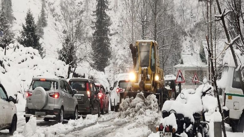
A fresh WD may lead to "very light" rain in the city on January 9 and the weather is likely to remain cloudy, the IMD said. Up north, the Srinagar-Jammu National Highway was shut for traffic for the fifth consecutive day in the wake of heavy snowfall over the past four days, even as the minimum temperature across the valley stayed below the freezing point.
The Kashmir Valley also remained cut-off from the rest of the country although the air traffic to and fro the valley was restored on Thursday morning. However, lack of snow clearance reroute to Srinagar airport led to massive traffic jams, forcing many passengers to travel several kilometres by foot. The heavy snowfall threw life out of gear in the valley with the administration pressing men and machinery into service to clear the roads of snow. Meanwhile, the Meteorological (MeT) office has said the weather is likely to remain mainly dry till January 14. Srinagar city, the summer capital of Jammu and Kashmir, recorded a low of minus 0.8 degrees Celsius, while the minimum temperature in Gulmarg tourist resort settled at minus 8.4 degrees Celsius compared to minus 3.5 degrees Celsius a night earlier.
In Himachal Pradesh, Keylong, Kalpa and Manali shivered at sub-zero temperatures as the mercury dropped by three to four notches after recent snowfall in the state. Keylong received 15 cm snowfall in the last 24 hours, followed by Kalpa (6 cm) and Pooh and Kothi (5 cm each), officials said, adding that some other parts, including Reckong Peo (23 mm), Nadaun (13 mm), Dalhousie (12 mm), Dharamshala (11.8 mm), Manali (9 mm) and Chamba (8 mm) witnessed light rain in the last 24 hours.
The tribal Lahaul and Spiti's administrative centre Keylong continued to be the coldest place in the state at minus 11.6 degrees Celsius. Meanwhile, cold weather conditions continued in Punjab and Haryana even as the minimum temperatures stayed above normal levels in both the states.
Chandigarh, the joint capital of Punjab and Haryana, recorded its low at 12 degrees Celsius, seven degrees above normal, while in Punjab, Amritsar, Ludhiana and Patiala recorded their respective minimums at 9, 12 and 13.5 degrees Celsius, up to seven degrees above normal. In neighbouring Haryana, Ambala, Hisar and Karnal recorded their respective lows at 12.1, 11.9 and 13.2 degrees Celsius, up to six degrees above normal.
In Rajasthan, night temperature continued to stay above normal in parts of the state, barring Mount Abu which recorded a low of minus 1 degree Celsius. In plains, Phalodi was the coldest place as it recorded a minimum of 5.6 degrees Celsius, officials said, adding that the weather conditions would remain the same during the next 24 hours.
Light to moderate rains accompanied by thundershowers occurred at few places over western Uttar Pradesh but the weather remained dry over eastern parts of the state in the past 24 hours. Day temperatures showed a marked rise in Gorakhpur and Prayagraj divisions with an appreciable increase in Varanasi, Ayodhya and Jhansi divisions.
In the south, a yellow alert has been sounded in the coastal and Malnad regions of Karnataka as the upper air cyclonic circulation brought heavy showers in many parts of the state on Thursday. The yellow alert was sounded for Dakshina Kannada, Uttara Kannada, Udupi, Chikkamagaluru, Hassan, Kodagu and Shivamogga for the next two days.
The KSDMA said most districts of Karnataka state are likely to receive "fairly widespread to widespread with light to moderate rains and at isolated places heavy to very heavy rains associated with thunder activity during the next 48 hours." According to the officials, there was rainfall in Shivamogga, Kodagu, Kalaburagi, Bengaluru, Mandya, Ramanagara, Hubballi-Dharwad, Udupi, Dakshina Kannada, Chikkamagaluru, Ballari and Hassan for the past two days.
Read all the Latest News, Breaking News and Coronavirus News here


Comments
0 comment